|
|
Baker Point Fire LookoutLocated in the United States Forest Service's,Sequoia National Forest, Hot Springs Ranger District |
![]()
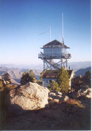
Baker Point's GPS location is 35.85278°N / 118.5025°W, Placed on the National Historic Lookout Register on 3/10/2001 as Lookout No. 376 |
![]()
|
Are you interested in becoming a Volunteer or Volunteer Fire Lookout, then visit the Buck Rock Foundation's Web-Site for further information. |
|
Baker Point Lookout is located in the Hot Springs District of the Sequoia National Forest in Township 24 S., Range 32 E., Section 10, and overlooks the Upper Kern River Canyon to the east as well as the west face of the Kern Plateau and to the west multiple drainages of the Bull Run Basin and Northeast slopes of the Greenhorn Range. Sitting at 7,754 feet, the Baker Point Lookout hovers on a granite peak 5,000 feet above the Kern River north of Kernville. Baker is non operational at this time, except it is still used as an important repeater location for canyon traffic, Cannel District traffic, Hot Springs traffic, Tulle District traffic and Greenhorn traffic for the forest and law enforcement communications. The trail to Baker is over grown and has several dead falls across it and is rough to follow, but the view in the canyon is spectacular for those who manage the trek. Anchor bolts found in a rock know north of the base of the current lookout suggest that a first and original building was constructed at Baker Points. Maps indicate this structure was built around 1943, and there is evidence that it was a 7x7 observation only wooden cab and tower lookout. The current lookout was built in 1950‘s overlooks the lower reaches of the Lake Isabella and Kern River areas, both very heavy recreational areas. Baker Point is used to serve as the main communication link between Forest Service personnel in those areas and the District Headquarters, as well as the main link between all of the other fire lookouts south of the Great Western Divide. The entire structure is wood and cost approximately $5,000 to construct. The cab is a 14x14‘ “C-3-L” or “L-6” live-in style building. The tower is of non-battered, open, treated timber construction. The height from the ground to the floor of the cab is 20 feet. All of the materials for construction were packed by in by horse and mule. During construction, two pack animals were killed when a portion of the original trail gave away. Since then another horse lost his life while packing in supplies. Standing next to the lookout is a one room wooden cabin that was built in 1943. Baker Point has not been used for fire detection for many years and is in need of major repair work. The trail, which goes through a granite rock slide area and is tricky to follow, is two miles from parking area to the lookout Mark Thornton gives Baker Point 24 points for historical significance in “Fire Lookout Evaluation Report” of 1988, making it eligible for the National Register of Historic Places. The lookout structure is not staffed and is currently closed to the public. Some of the information is courtsey of Buck Rock Foundation. |
![]()
| These are private web pages and are not maintained by any governmental agency, all representations are for educational and informational purposes only! See Disclaimer and Legal Stuff for more details. |
1995 Miami Mountain Volunteer Fire Lookouts
fire-lookouts.org
All Rights Reserved